The first three days of the trip so far had been absolutely perfect for a motorcyclist: Clear skies and cool temps. But by the time I pulled into my stop for the third night in Gillette, Wyoming, I knew my luck was about to run out. I’d been watching the weather, as we pilots and motorcyclists do. I knew there was rain ahead. If only…
I have a good rainsuit. Westbound out of Gillette, I had it on but only experienced light showers. I got just past the town of Sheridan before I saw a sign that said, “Interstate 90 closed ahead. All traffic must exit. Use Rt 14 westbound.” I was like, WTF? They close the Interstates up here? Indeed they do. Westbound was not the direction I needed to be going.
The Buffalo River had flooded way up at the town of Hardin, Montana, some 66 miles ahead. There really aren’t any alternate routes, so they kicked us off the Interstate at the town of Ranchester, just south of the Montana border. Highway 14 took us through the Bighorn National Forest.

Our little detour. If you click on the image it'll open bigger. See that road about halfway through the Bighorn National Forest that looks like a shortcut over to the town of Lovell? Yeah...it was closed due to the heavy snowfall. The detour added nearly 60 miles of bad road to the trip. Doesn't seem like a lot, right?
It was raining steadily now. My paper map showed us heading way off to the southwest, when I really needed to be going almost straight northbound. Just past the town of Dayton we started up a steep grade with lots of switchbacks. Dear God, it was slippery. I thought to myself, “This is not good.” One complication was that I do not have a smart-phone, only a very, very dumb one. This was a calculated risk, as it would have been nice to be able to get online and see the current weather and figure out a better alternate route.
I hoped it would be a quick up-and-over a pass, but we just kept climbing and climbing. And it got colder and colder. I could see we were climbing up into a cloud deck. Soon, visibility dropped to a couple of hundred feet. There was snow falling, snow on the ground all around me and, occasionally, snow on the road. To say I was dispirited would be the understatement of the year. I really wasn’t prepared to ride in snow.
 A satellite view of the road through the Bighorn National Forest (obviously taken in the Spring or Summer). Silly me for thinking I'd be through it quickly.
We’d ascend, and then descend a little and I’d get my hopes up. But then we’d ascend again. The FAA chart of the area shows peaks of 10,000 feet. The road doesn’t go across the tops of the peaks of course, but we weren’t too far from the top. I saw one of those elevation signs that said something like 8,000 feet. I was too cold to stop and take a picture. And we were not yet on the way down. All I could do was ride as carefully as I could, hoping I didn’t drop the bike on one of the sharp curves. The scenic turnoffs were all closed and impassable due to the snow.
 ABOVE: About halfway up the pic, where the horizon ought to be, are clouds and snow-covered mountains hidden behind them. This was the first chance I had to pull over and take a picture.
 This was what it was like for most of the trip through the B.H. National Forest. Except sometimes it was snowing more heavily (which you can't see in the pic).
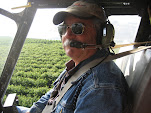
 In the two pictures above, I had descended below the snow line. The pictures can't communicate how cold it was. I was just happy to be out of the clouds and snow.
After what seemed like forever, we descended into the "town" of Shell (which isn't, really), then further down to Greybull where it really started raining again. It’s funny, 50 degrees seemed so cold just a few hours earlier. Now, 50 in a steady rain felt like summer in the friggin’ Bahamas compared to what I’d just been through.
Google Maps shows that it’s about 47 miles on Rt. 14 from one side of the Bighorn National Forest to the other. Forty-seven winding, hilly miles. It would have been awesome on a good-weather day...in the dead of summer!, but I will admit that it was a pretty stressful, difficult ride when I went through. I didn't know it but things were about to get even worse.
3 comments:
I used to think you had good sense! I will admit however you still have "cahonas". I cannot imagine the ride you are describing, but hope the journey is worth it!
Take care,
Cass
What a story! (As I read from the comfort of AC while sipping a Bud Light . . . )
Can't wait for the next installment.
The good news is: I know you got there!
Cass and Bob, yeah it was not an easy trip - at least the last half, but it absolutely *was* worth it. More installments to come.
Post a Comment